CSI Mapping
CSI Mapping
  • Home
  • Forensic Mapping
  • Aerial Mapping
    • Microdrones
    • Pilot Training
  • Mapping Equipment
    • Total Stations
    • GPS
    • GPS Network
    • Laser Scanning
    • Data Collectors
  • Software
    • Forensic CAD
    • Animation
    • PointCloud
    • Evidence Recorder
    • Magnet Field
  • Live Chat
  • Documents & Files
  • Calendar
  • Keson
  • About Us
  • More
    • Home
    • Forensic Mapping
    • Aerial Mapping
      • Microdrones
      • Pilot Training
    • Mapping Equipment
      • Total Stations
      • GPS
      • GPS Network
      • Laser Scanning
      • Data Collectors
    • Software
      • Forensic CAD
      • Animation
      • PointCloud
      • Evidence Recorder
      • Magnet Field
    • Live Chat
    • Documents & Files
    • Calendar
    • Keson
    • About Us

  • Home
  • Forensic Mapping
  • Aerial Mapping
    • Microdrones
    • Pilot Training
  • Mapping Equipment
    • Total Stations
    • GPS
    • GPS Network
    • Laser Scanning
    • Data Collectors
  • Software
    • Forensic CAD
    • Animation
    • PointCloud
    • Evidence Recorder
    • Magnet Field
  • Live Chat
  • Documents & Files
  • Calendar
  • Keson
  • About Us

Forensic Mapping with Drones - podcast

Meet Steve, Kris, Curt and Rick

CSI Mapping
Microdrones
Aerial Mapping Training
Drones
Drones Training
Point Cloud
Photomesh

mdMapper

More than 1000 Businesses Worldwide Trust MICRODRONES®

Since 2005, their passionate team of aircraft engineers, software developers and payload integration experts have lead the market for professional drone applications.


Precision mapping and public safety are done more efficiently and effectively with the help of Microdrones solutions. 


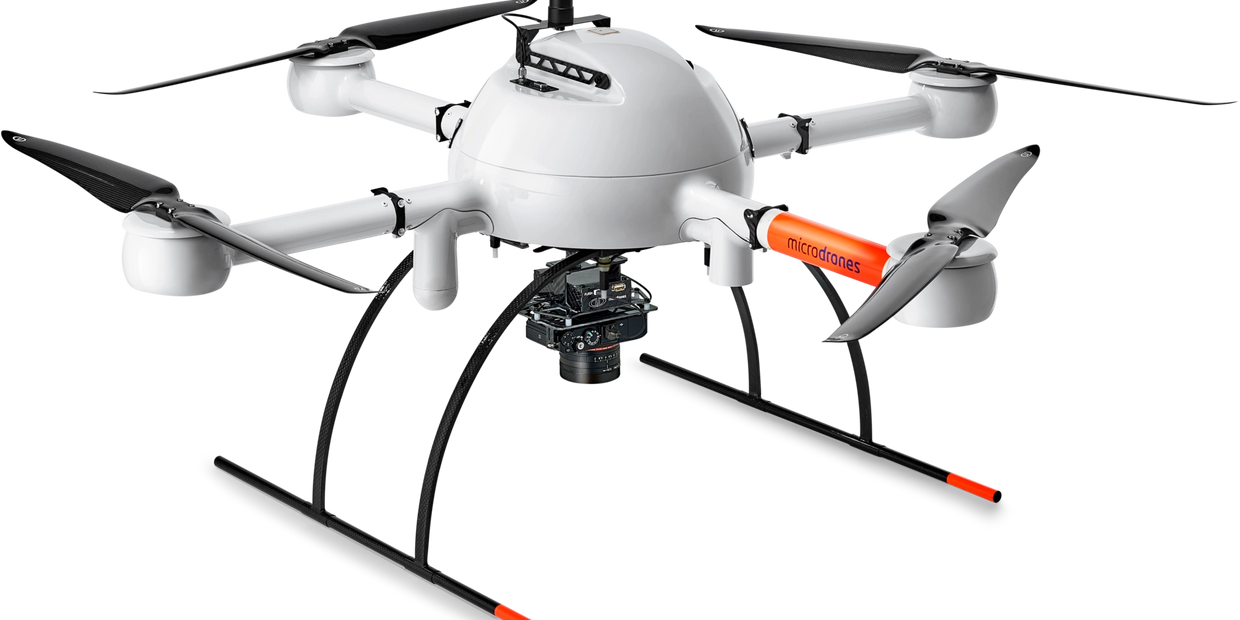
The Microdrones heritage of German engineering is carried through the Sentire aircraft design, resulting in industry-leading flight times, incredible resistance to harsh conditions, and smart integration.


Rain and Heat Resistant

The Microdrones molding process keeps electronics and wiring protected from the elements. Our system is resistant to rain, sand and salt, so you can fly in harsh conditions.


Failsafe Motors for Minimum Downtime

Brushless, low RPM motors and large props work seamlessly for the life of your airframe. In 10 years of operation, an md4 customer has never reported a failure related directly to our motors.


Stable Flight for Precise Results

Our micro-controlled drive system instantly responds to changing winds to maintain the proper flight attitude. For mapping, stable flight delivers more accurate and precise data.


A Plus for Stability and Endurance

Our plus sign (+) shaped configuration is more practical. With a motor on the front, the rear and  each side, the airframe remains more stable in level flight and during turns. With less energy being consumed for stability, the extra power goes to carrying heavier payloads.


Tested for High Voltage Fields

Those who intend to fly their Microdrones UAV near power lines can do so with confidence, knowing our quadcopters were rigorously tested for interference up to 380 kV in the high-voltage laboratory of the Technical University Dresden.


Paper

​Collision Scene Reconstruction and Investigation Using Unmanned Aircraft Systems


In August 2017 The North Carolina Department of Transportation Division of Aviation released a study of the their combined work with the North Carolina State Highway Patrol Collision Reconstruction Unit.

​"Based on these findings, we believe that time spent at collision sites can be dramatically reduced by using UAS technology, allowing for rapid restoration of traffic flow and the safety of investigative members."​ N.C. State Highway Patrol Collision Reconstruction Unit

​Read the study to see how suitable UAVs are for replacing 3D scans by the FARO Focus 3D X330 Laser Scanner for daytime scenes.

PDF Link

Case Study

You Tube Video Link

Case Study

Safe, reliable flights producing accurate results is what you should expect from your drone or unmanned aerial system.

Web Link

Paper

You Tube Video Link

Case Study

Positional Quality Assessment of Orthophotos Obtained from Sensors Onboard Multi-Rotor UAV Platforms

Web link

You Tube Video Link

You Tube Video Link

You Tube Video Link

Discovery - How Machines Work

Microdrone md4-200

Youtube link

Paper

Paper

You Tube Video Link

Accuracy assessment of direct georeferencing for photogrammetric applications on Unmanned Aerial System platforms.

PDF link

Paper

Paper

Paper

Direct georeferencing on small UAS platforms for improved reliability and accuracy of mapping without the need for ground control points

pdf link

Study

Paper

Paper

Low-Light Collision Scene Reconstruction Using Unmanned Aerial Systems

pdf link

Copyright © 2023 CSI Mapping  - All Rights Reserved.

  • Home
  • Microdrones
  • Total Stations
  • Forensic CAD
  • Live Chat
  • Documents & Files
  • Calendar
  • About Us

Cookie Policy

This website uses cookies. By continuing to use this site, you accept our use of cookies.

DeclineAccept & Close